47°F

Aaron Parecki

  • Articles
  • Notes
  • Photos

#gps

  • Simplify.js - a high-performance JavaScript 2D/3D polyline simplification library (mourner.github.io)
    #gps #resources #polyline #ramerdouglaspeucker #maps
    Wed, Feb 6, 2019 10:36pm -05:00
  • Aaron Parecki
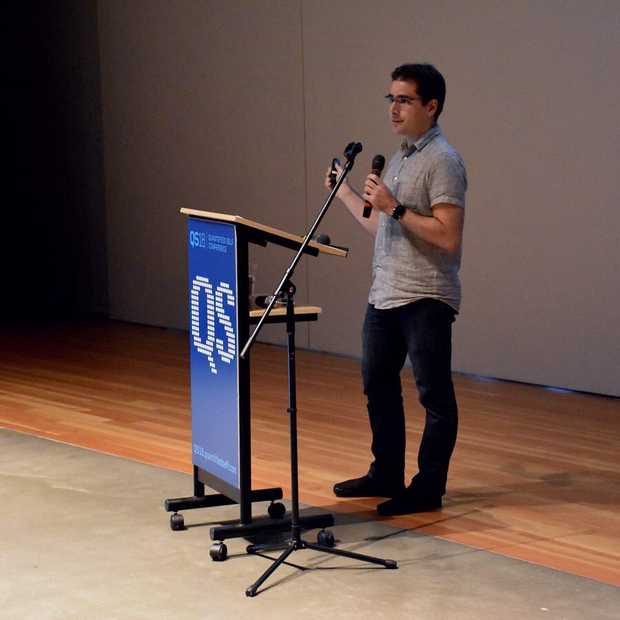
    This year I reached the ten year mark of continuously tracking my location! Very happy to have had a chance to share the project at #qs18!

    #gps #location #quantifiedself
    Ziba in Portland, Oregon, USA
    52 likes 1 repost 9 replies 1 mention
    #qs18 #gps #location #quantifiedself
    Sun, Sep 23, 2018 12:54pm -07:00
  • Ten Years of Tracking My Location
    Sep
    23
    September 23, 2018 12:00am (+0000)
    Ziba Auditorium
    Portland, Oregon, US
    Quantified Self 2018
    View Slides
    Watch Video
    #gps #location #qs #quantifiedself
    permalink
  • Quantified Self 2018
    Sep
    22
    Sep
    23
    September 22-23, 2018
    Ziba Design
    Portland, Oregon, US
    #qs #gps #quantifiedself
    permalink
  • Aaron Parecki
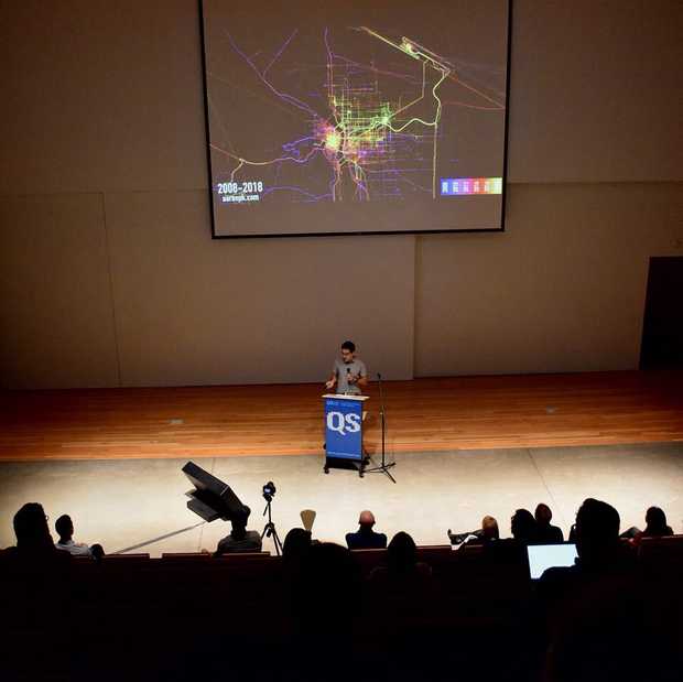
    RIP https://www.moves-app.com

    You can use my location tracking app as a replacement, tho it requires you set up your own backend for it. But at least that way you're the only one who can decide to shut it down!

    https://overland.p3k.io
    Portland, Oregon, USA • 70°F
    7 likes 3 reposts 2 replies 1 mention
    #gps #location #moves #overland
    Tue, Jul 3, 2018 3:47pm -07:00
  • Location history sans Google | ma.rtijn.org (ma.rtijn.org)
    #gps #location #overland #compass
    Fri, Mar 2, 2018 2:09pm -08:00
  • Inside a low budget consumer hardware espionage implant (ha.cking.ch)
    #gps #spy #technology #teardown
    Sun, Nov 12, 2017 10:40am -08:00
  • Aaron Parecki
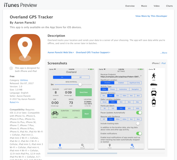
    My GPS tracking app is live in the App Store! It's ugly, but it works, and now you can use it too! https://overland.p3k.io
    Portland, Oregon, USA
    25 likes 7 reposts 13 replies 2 mentions
    #overland #gps #ios
    Sat, Oct 7, 2017 9:05am -07:00
  • Particle Tutorials | Google Maps (docs.particle.io)
    #particle #gps #google #maps #electronics
    Wed, May 24, 2017 7:42am -07:00
  • I'm Still Here!

    I just added my favorite new relatively unimportant feature to my website!
    continue reading...
    2 likes 1 reply 1 mention
    #p3k #indieweb #checkins #gps
    Fri, May 19, 2017 6:31pm +02:00
  • BeeLine GPS (www.bigredbee.com)
    #gps #aprs #hamradio
    Mon, Mar 27, 2017 7:29am -07:00
  • Beeline (beeline.co)
    #cycling #gps #navigation #touring
    Mon, Mar 27, 2017 7:27am -07:00
  • Aaron Parecki
    Do I know anyone with a Spot Trace who wants to send me a referral code?
    Portland, Oregon, USA
    1 repost 2 replies
    #spot #gps
    Wed, Mar 15, 2017 6:28pm -07:00
  • Day 64: Documentation and Fixes for my GPS Logger App #100DaysOfIndieWeb

    I track my location continuously using an iOS app I wrote a few years ago. The app is not published on the app store, but it is open source. Today I added a bunch of documentation describing what all the controls in the interface are for.
    continue reading...
    2 mentions
    #100daysofindieweb #gps #ios
    Wed, Feb 22, 2017 12:48pm -08:00
  • PicoAPRS - Word's smallest APRS Transceiver (Tracker) with KISS-TNC by DB1NTO (www.db1nto.de)
    #aprs #gps #hamradio
    Sun, Feb 19, 2017 9:15am -08:00
  • Tracksoar | Open source APRS tracker (www.tracksoar.com)
    #aprs #hamradio #gps
    Sun, Feb 19, 2017 9:14am -08:00
  • It's done! The smallest APRS Transceiver on the World? (Page 1) / Hardware / Unsigned.IO Forum (unsigned.io)
    #aprs #gps
    Fri, Feb 17, 2017 1:10pm -08:00
  • Byonics - MicroTrak (www.byonics.com)
    #gps #hamradio
    Wed, Dec 7, 2016 8:42am -08:00
  • lat lon - Measuring accuracy of latitude and longitude? - Geographic Information Systems Stack Exchange (gis.stackexchange.com)
    "Using these ideas we can construct a table of what each digit in a decimal degree signifies:

    The sign tells us whether we are north or south, east or west on the globe.
    A nonzero hundreds digit tells us we're using longitude, not latitude!
    • The tens digit gives a position to about 1,000 kilometers. It gives us useful information about what continent or ocean we are on.
    • The units digit (one decimal degree) gives a position up to 111 kilometers (60 nautical miles, about 69 miles). It can tell us roughly what large state or country we are in.
    • The first decimal place is worth up to 11.1 km: it can distinguish the position of one large city from a neighboring large city.
    • The second decimal place is worth up to 1.1 km: it can separate one village from the next.
    • The third decimal place is worth up to 110 m: it can identify a large agricultural field or institutional campus.
    • The fourth decimal place is worth up to 11 m: it can identify a parcel of land. It is comparable to the typical accuracy of an uncorrected GPS unit with no interference.
    • The fifth decimal place is worth up to 1.1 m: it distinguish trees from each other. Accuracy to this level with commercial GPS units can only be achieved with differential correction.
    • The sixth decimal place is worth up to 0.11 m: you can use this for laying out structures in detail, for designing landscapes, building roads. It should be more than good enough for tracking movements of glaciers and rivers. This can be achieved by taking painstaking measures with GPS, such as differentially corrected GPS.
    • The seventh decimal place is worth up to 11 mm: this is good for much surveying and is near the limit of what GPS-based techniques can achieve.
    • The eighth decimal place is worth up to 1.1 mm: this is good for charting motions of tectonic plates and movements of volcanoes. Permanent, corrected, constantly-running GPS base stations might be able to achieve this level of accuracy.
    • The ninth decimal place is worth up to 110 microns: we are getting into the range of microscopy. For almost any conceivable application with earth positions, this is overkill and will be more precise than the accuracy of any surveying device.
    • Ten or more decimal places indicates a computer or calculator was used and that no attention was paid to the fact that the extra decimals are useless. Be careful, because unless you are the one reading these numbers off the device, this can indicate low quality processing!"
    #gps
    Mon, Oct 17, 2016 8:33pm -07:00
  • Neighbor-Finding Based on Space-Filling Curves (db.cse.nsysu.edu.tw)
    "Nearest neighbor-finding is one of the most important spatial operations in the field of spatial
    data structures concerned with proximity. Because the goal of the space-filling curves
    is to preserve the spatial proximity, the nearest neighbor queries can be handled by these
    space-filling curves."
    #curve #spacefillingcurve #gps
    Sun, Sep 25, 2016 12:22am +01:00
next

Hi, I'm Aaron Parecki, co-founder of IndieWebCamp. I maintain oauth.net, write and consult about OAuth, and am the editor of several W3C specifications. I help people learn about video production and livestreaming.

I've been tracking my location since 2008 and I wrote 100 songs in 100 days. I've spoken at conferences around the world about owning your data, OAuth, quantified self, and explained why R is a vowel. Read more.

  • Security Architect at Okta
  • IndieWebCamp Founder
  • OAuth WG Member

  • ⭐️ Life Stack
  • ⚙️ Home Automation
  • 🎥 YouTube
  • All
  • Articles
  • Bookmarks
  • Notes
  • Photos
  • Replies
  • Reviews
  • Sleep
  • Trips
  • Videos
  • Contact
© 1999-2021 by Aaron Parecki. Powered by p3k. This site supports Webmention.
Except where otherwise noted, text content on this site is licensed under a Creative Commons Attribution 3.0 License.
IndieWebCamp Microformats Webmention W3C HTML5 Creative Commons